Clydebelt News  - Kilpatrick Hills & surrounding towns
  • Clydebelt News page
  • About Clydebelt
  • contact Clydebelt
  • Clydebelt archive website

The Great Outdoors Festival     31st August-8th September

18/8/2013

0 Comments

 
 This is the third year of this festival with events across East and West Dunbartonshire and Stirling. 
The brochure can be seen by following links on the WDC website or available from libraries etc.  
There are several events around the Kilpatricks.

Clydebelt and Clydebank Local History Society are repeating the ‘Solve the Mystery of the Stones’ on Sunday 1st September on Carleith Muir and also the ‘Antonine Wall Wander’ on September 8th, following the Roman Wall from Old Kilpatrick Fort to Castlehill Fort.

Others to be recommended are ‘The Craigs Circular’ a walk guided by the Forestry Commission and Woodland Trust round the Lang Craigs above Dumbarton, and a walk from Mugdock to Faifley along the Bankies Trail. With forty eight events for all degrees of fitness and varied interest, there should be something to entice you out into the Great Outdoors.

More on the Woodland Trust’s Lang Craigs and improvements at Overtoun estate can be seen on the Silverton and Overtoun Community Council’s excellent newsletter. 

The forestry commission have a website and contact.
0 Comments

Posties Park Levengrove Dumbarton

17/8/2013

0 Comments

 
Do you know about West Dunbartonshire Council's idea to build the new Our Lady and St. Pat's secondary school on Posties Park, next to Levengrove?  
This is a large open green space, bounded by the Clyde, the Leven, and Levengrove Park. An ideal site, from WDC point of view, to build a new school. A campaign against this is mounting, and there is now a 'Save Postie's Park' site on Facebook.

There is also a petition .

In brief, this would be against WDC adopted Local Plan (listed as retained public open greenspace) and has some relevant European environmental legislation (redshanks on the shore) a great deal of public opposition and a reasonable alternative - the existing site. 

The National Pipe Band Championships (or any similar open air events) would also not be held here after 2015; it is an ideal site and is probably Dumbarton's major event.

WDC have done test drilling, and a report goes back to the Education Committee in September. This has to be followed (if they confirm their preference) by a Pre-application Consultation (comments by the public must be noted), a planning application (formal objections must be heard), and finally, because the land is owned by WDC and is against their own Local Plan, it will be called-in by the Scottish Government, for a final decision by a Reporter (all comments, objections, etc. etc. must be taken into consideration).

Postie’s Park was given to the local authority in 1872 in substitution for rental sums due to the Town Council, and (unfortunately) does not form part of Dumbarton Common Good. Protection therefore rests on the Adopted Local Plan being respected. Comments can be made at the Pre-application stage, and formal comments at the Planning Application stage, although there is nothing to stop individuals writing to their local councillors at this stage.

Clydebelt’s committee will be objecting to the choice of this site to WDC. See also http://www.lennoxherald.co.uk/dunbartonshire-news/dunbartonshire-news/dumbarton-news/2013/06/07/bill-heaney-posties-is-the-people-s-park-114557-33426517/  and other press comment.

0 Comments
    Picture

    Clydebelt 

    This news/blog site continues from an earlier one at:

    Clydebelt's 2009-2011 blog
    Clydebelt original site
    email Clydebelt
    Kilpatrick Hills on Flickr

    Archives

    November 2015
    April 2015
    March 2015
    January 2015
    November 2014
    July 2014
    April 2014
    January 2014
    November 2013
    October 2013
    August 2013
    May 2013
    April 2013
    January 2013
    December 2012
    November 2012
    September 2012
    June 2012
    April 2012
    March 2012
    January 2012
    March 2011

    Categories

    All
    Forestry
    Greenbelt
    Kilpatrick Hills
    Local Plan
    Meeting
    Planning Issue
    Quarry
    Windfarm

    RSS Feed

    Picture
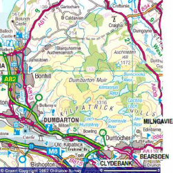
    Pop-up image of road map produced from the Ordnance Survey Get-a-map service. Image reproduced with kind permission of Ordnance Survey.
Powered by Create your own unique website with customizable templates.