Clydebelt News  - Kilpatrick Hills & surrounding towns
  • Clydebelt News page
  • About Clydebelt
  • contact Clydebelt
  • Clydebelt archive website

June 17th, 2017

17/6/2017

0 Comments


This blog site is no longer updated.

Subscribe to our emails for the latest news

or join the Clydebelt Facebook Group


0 Comments

Join Clydebelt for more news

16/11/2015

0 Comments

 
Clydebelt members who have subscribed to emails get more news than go onto this site about good and bad things around the Kilpatrick Hills .

We continue to try and keep our membership list up to date. If you are not able to come to the AGM on Tuesday, then please get in touch by email or phone, and let us know, to indicate your continued interest. (contact with the menu item above).
0 Comments

a new Secretary

16/11/2015

0 Comments

 
Clydebelt is now seeking a new Secretary to take on the campaigning role that Sam Gibson has done so well for the past fifteen years. He will be stepping down in November, and so if you think that you – or someone you know – would like to take on this role (with lots of support from the Chairman, other elected officers and the Committee) – then please do come forward! We are not confident about how the organisation can continue without this pivotal role being in place.

Clydebelt is also looking for more Committee members to actively support our work. Please consider joining us – you will be made very welcome! Meetings are held every two months, on a Tuesday evening.
0 Comments

Coming to the AGM on Tuesday?

16/11/2015

0 Comments

 
   Note --- Due to closure of the road through Duntocher access from the A82 can only be made from the Kilbowie Roundabout and first left into Milton Douglas/Roman Road.

Old Street in Duntocher is also closed and access has to be from Hardgate Roundabout and Kilbowie Road to Milton Douglas/Roman Road or park in Dumbarton Road Duntocher and walk across into Roman Road.

0 Comments

Bowling Basin

15/11/2015

0 Comments

 
Scottish Canals are about to submit their plans (Masterplan!) for major development around Bowling Basin. This follows on from the public charrettes held last year. As was expected this will include housing development on both sides of the canal, new roads and a new bridge east of the top lock. It will impact significantly on both villages - e.g. the two-lane access bridge connecting single-lane access roads either side of the canal suggests there will be another access road built at some point.

Bowling Community Council has details and a survey on this website www.bowlingsurvey.org.uk The plans will affect residents in both villages as well as the enjoyment of the many who walk and cycle along the canal. Please take a minute or two to look at the proposals and do the survey. http://www.bowlingbasin.com/news-events/bowling-basin-masterplan/

0 Comments

Access to the Kilpatrick Hills at Old Kilpatrick

15/11/2015

0 Comments

 
Over the past two years, the number of walkers and cyclists in the Kilpatrick Hills has increased. At weekends and on fine days the narrow access road at the bottom, which leads past the gas governor station and up to the Rosie Road, was often lined on both sides with cars. This was causing concern on the part of the farmers and other residents who live up in the hills; at times there was barely enough space for farm machinery to get through. Emergency vehicles could also have had a problem getting through. There are approximately fifteen separate dwellings - including a farm - accessed from that small road.

The Council agreed to put barriers up each side of the lane to discourage people from parking there, in order to keep the lane free for local traffic and emergency traffic. At the same time as the barriers were put up, signs were put up directing walkers to park their cars up near the O.K. Bowling Club. Admittedly it's not an immediately obvious route there, but signs have been put up directing cars to this parking area. (the signs read ‘P’ Kilpatrick Hills’). Drive up Mount Pleasant Drive, and once at the top turn left over a small bridge that takes you towards the Bowling Club. Parking spaces can be found on the grass there, with additional parking, some 50 m. further along on the left - there is a fair amount of space.

Some people are ignoring the barriers but on the whole there has been a marked improvement, and reduction of the traffic problem at the bottom of the road to the Hills. So next time you are in the area, you’ll spot the signs leading to the new parking area. On a clear day, it is a beautiful walk. There is a steady climb up to the top of the Braes, which is steep for one or two short sections only. The views open up more and more as you get higher up: down the Clyde as it widens towards the Firth, and also back and across over Glasgow. Once at the top, there are miles of tracks and paths, and various lochs. A good walk from the Dumbarton end is up through Overtoun to the Crags, on to the Black Linn through the new forestry path, now much improved, to the west end of Loch, Humphrey and then down the Braes - much easier than going up! You can then get a train back to Dumbarton from Old Kilpatrick.

Forest Enterprise are hoping, in a long term plan, to find a parking solution that is closer to the Kilpatrick Braes so that visitors have easier access to the hills and reduce the impact on residents.
E.P.
0 Comments

Cochno Filters

14/11/2015

0 Comments

 
The well-known landmark, the Water Tower and Treatment Works at the top of Cochno Road, is no more. It was the meeting place and starting point for many walkers heading for Greenside Reservoir, Duncolm and beyond.

Our attempt to save the mosaic coat of arms for the Clydebank and District Water Trust was in vain; the agents for the developers saying it was no longer there or vandalised. Why did Scottish Water not try to have it removed for posterity when they sold the building for demolition? Does no one care about such things anymore? Despite the information from the agents, it can be seen on the following. http://www.karenbrodiephotography.co.uk/p190575133 http://www.28dayslater.co.uk/cochno-waterworks-12-06-12.t71860 https://www.youtube.com/watch?v=9PFW4CH7CLU

Water purification is now all done at the Burncrooks Treatment Works: the lochs and reservoirs being all interconnected by pump or gravity feeds. Water flows back to Cochno where there are still underground tanks for distribution to most of Clydebank. Planning permission has been granted for a 75 bed nursing home on the site and an application for 11 houses is pending a decision.
0 Comments

CLYDEBELT ANNUAL GENERAL MEETING and 25th Anniversary celebration          17th November 2015

2/11/2015

0 Comments


The AGM of Clydebelt will be held in Trinity Church Hall, Roman Road, Duntocher at 7.30 pm on Tuesday 17th November 2015                   

AGM Agenda

1.    Apologies
2.    Minutes of last AGM
3.    Matters arising
4.    Secretary’s report
5.    Treasurer’s report
6.    New  Secretary
7.    Election of Officers and new committee members
8.    A.O.C.B.
----< >----
Come and celebrate 25 years of Clydebelt’s activities and achievements.
 ----<  >----
Display of photographs and articles
----<  >----
Buffet refreshments                Wine and soft drinks


It’s that time of the year again, and we hope that many of our
members will show their support by joining us for the
 AGM at 7.30 on Tuesday 17th November.  After the meeting  
there will be buffet refreshments with wine, soft drinks, tea and coffee,
and a chance to celebrate the 25 years that Clydebelt has been working
to protect the Hills and surrounding area.  Display boards will show
some examples of these projects, from the beginning of Clydebelt in
1990.

Clydebelt is now seeking a new Secretary to take on the campaigning
role that Sam Gibson has done so well for the past  fifteen years.   
He will be stepping down in November, and so if you think that you –
or someone you know – would like to take on this role (with lots of
support from the Chairman, other elected officers and the Committee)
 – then please do come forward!  We are not confident about how the
Organisation can continue without this pivotal role being in place.

Clydebelt is also looking for more Committee members to actively
support our work.  Please consider joining us – you will be made
 very welcome! Meetings are held every two months, on a Tuesday
evening. Our website http://www.clydebelt.org.uk/ has been slightly  
updated and blogs are added here where you can see our past Newsletters. We would welcome anyone with the ability to modernise and run our site.
      
We continue to try and keep our membership list up to date.  If you are
not able to come to the AGM, then please get in touch by email or phone,
and let us know,  to indicate your continued interest.

If you have any interest in  any  aspects of the Kilpatrick Hills and the environment of surrounding areas, please comealong to the AGM, November 17th 7.30 Trinity Church Duntocher. Whether you are a member or not we will be glad of your support  and are also willing to listen to your concerns.


0 Comments

Newsletter  April 2015

11/4/2015

0 Comments


With the coming of spring and some pleasant weather,   just a little of the despondency displayed in our last newsletter has lifted. (see below)                                 

 Duntiglennan Fields
At the WDC planning meeting on 26th March, the planning  committee unanimously voted NOT to accept the Local Development Plan examination report submitted by the Scottish Government’s Directorate of Planning and Environmental Appeals (DPEA). This report was returning the ‘Duntiglennan Fields ‘ back to a housing opportunity site for up to 100 houses  and the committee want the status reversed back to ‘Green Belt’ which was what the hard fought battle was about and what we thought had been achieved in the earlier stages of the plans progress. Perhaps all this hassle could have been avoided if the WDC officials had not suggested the site for housing in the first place but we would suppose they do take cognisance of the desires of the owners and potential developers. It was obvious from the opposition to the proposed removal of the sites from green belt at the previous plan’s formation five years ago that this was a contentious issue.  The reporter on that occasion ruled against housing.  Has green belt land now become a ‘land bank’ for speculators knowing it will eventually be released for housing at future revisions of the local plan?                                                                                                          

   In a similar situation, also in Hardgate, the planning department recommended housing in the former mill dam despite having previously declared it part of a riverside wildlife corridor. There was also opposition to this from residents, Clydebelt and planning committee councillors but was also pushed through by the DPEA. The site is now lying as an eyesore, destroyed and derelict after the developers pulled out after having started the ground works.
What the next episode of the Duntiglennan saga will be, we do not know, but Provost Douglas McAllister says he had taken legal advice before putting the motion for the council not to accept the DPEA report with regards to the Duntiglennan issue only.

Report from Public Meeting No 1  Charrette - 11th-14th February
…..“The Scottish Government has selected Clydebank town centre for a major locally driven
design charrette….. the fundamental aim is to involve local residents, business and stakeholders in planning the future of the town centre. A charrette is an intensive consultation that engages local people in the design of their community……..Planning and design workshops will be held in the Clydebank Town Hall over a four day period… when the public, designers and specialists will be working together, ‘hands on’, to prepare a long term vision, development framework and action plan for Clydebank Town Centre with the ideas translated into plans and drawings…
.”
This charrette was only originally to discuss Clydebank town centre which is now seen as only the Shopping Centre. The few oldies that turned up at the general public session perhaps convinced the enthusiastic and receptive young planners appointed by the Scottish Government, that Bankies considered the town centre should include the area around the Town hall and Library. Unfortunately our council leading officials are hell bent in destroying any semblance of a civic centre in Clydebank by closing the council offices at Rosebery Place, having previously priced local organisations out of the town hall. Our local museum has been replaced with a gallery mostly concentrating on art exhibitions from outwith the area and not showing the archaeology, history and artefacts of the local area which should be its main purpose.

Clydebank Re-built went through the same forum process nearly ten years ago; not just a couple of hours but over very many sessions and yet our young planners seemed not to have heard of it and no one seemed to know where all the information and ideas gathered then went. I am afraid we have seen and heard it before and have been waiting over 70 years since the blitz for some decent town planning. Don’t hold your breath for anything like a coordinated plan for the centre of Clydebank to arise from this. 
                                                                                                                   
There will be a further meeting to show the conclusions of the charrette shortly.
 http://www.west-dunbarton.gov.uk/planning-building-standards/clydebank-town-centre-design-charrette/
A similar charrette was held in Dumbarton focusing on the Castle Rock and surrounding areas and we hear there were many positive suggestions which were favourably received
http://www.west-dunbarton.gov.uk/planning-building-standards/dumbarton-rock-charrette/


Report from Public Exhibition No2- January 22nd
This was held in the Clydebank College when agents for the developers showed plans for the possible development of Queen’s Quay (former John Brown’s shipyard). These were only indicative of what might be and opinions sought. Basically four storey flats would front along a riverside walkway with lower density housing with gardens, in the streets towards Dumbarton Road, This possibly would maximise the sales value by building what is currently the type of property in demand. Is this really the site for suburban type housing? Around the fitting out basin could be shops/cafes/ pubs /hotel, office space etc., with a small supermarket towards Glasgow Road. No indication of public open space provision, children’s play areas or a civic square to the south of the Town Hall as were in the suggestions once proposed by Clydebank Re-built. There is the possibility of new council nursing home and Health Centre nearer to Dumbarton Road. The meeting was not well attended and was not connected in any way with the above meeting on ‘Clydebank town centre’

Public Meeting 3
A meeting organised by Old Kilpatrick Community Council in January led to subsequent meetings and a group , several of whom take part in the Sunday litter picks at the Saltings are in the early stages of forming a community volunteers group.

Old Kilpatrick Community Group
It all began with litter picking in Lusset Glen and the Saltings, carried out by some local and not-so-local individuals. Then, Sandra Anton (Community Engagement Ranger), told us about some greenhouses that might be used by a community group.  With her support and that of Linda Adam, (Community Greenspace Officer), three meetings have been held at the Napier Hall, and a group of local volunteers interested in enhancing the village has emerged, focusing on the environment (e.g. litter issues), local history and archaeology (e.g. Antonine Wall), and horticulture (e.g. flowers to brighten up the village spaces).  

Although it is still early days, good progress is being made and plans are being formulated. The name, aim and objectives of the group are still to be finalised, and a more detailed report will be made at that time.  

 It is hoped to hold a Community ‘Launch Day’ on Saturday 20th June.  More details to follow!

Clydebelt’s 25th Anniversary
It will be 25 years since Clydebelt was formed after 400 people attended a public meeting in Trinity Church to oppose a massive planning application along the whole face of the Kilpatricks from Gavinburn to Edinbarnet.  Proposed was an exclusive leisure estate with golf courses and club houses, hotels, artificial ski slope, riding establishments, rural/rare breeds centre, corporate training and conference centre, parking for 2500 cars, new roads, etc.

We are intending to hold some kind of an event/buffet on the 13th or 14th November- save the dates: more precise details to follow.

History Ramble at Cochno/Edinbarnet/Auchnacraig  Wednesday 6th May 7.00 pm
As part of the 25th Anniversary celebrations we will have a short walk showing the varied history /natural history of this area.   
Druid and ring stones, bleach field, water powered sawmill, Lady’s Linn, Graveyard, stately country houses and bluebells.
Meet in the Auchnacraig car park on Cochno Road. As the ground can be rough, steep in a few places and wet, appropriate footwear is required.    And also

Walk to the Jaw Reservoir    Thursday 7th May 7.00pm
Circular walk of about 3 miles through Cochno and Edinbarnet estates to the Jaw Reservoir. Again from Auchnacraig car park.
For both please book and obtain any other details from Sam Gibson Tel 01389872490 or email

Hardgate Knowes- Clydebelt clean up- Sunday 19th April 10.00am – 2.00pm
Once again we are having what has become an annual clean up on Hardgate Knowes. Meet at the car park behind Whitehills Hotel (opposite Tesco) at Hardgate roundabout; equipment supplied. Treats being supplied by Greggs. We always come away wishing we had more volunteers to attack some of the more remote spots.  Please come along and show your support.

WDC clean ups take place on the Saltings on the first Sunday each month meeting in the car park off Erskine Ferry Road at 10.00 am

Explore Outdoors! Lang Craigs & Kilpatrick Hills
Saturday 30th May 11am – 3pm

Join the expedition with Forestry Commission Scotland & Woodland Trust Scotland to explore new trails and hidden areas of Lang Craigs & Kilpatrick Hills. Fun for explorers of all ages with children’s treasure hunts, geocaching and other fun family activities such as storytelling and camp fires.
Refreshments available on the day.
No booking required, drop in at any time.
Free of charge – parking available at Woodland Trust car park beside Overtoun House’.
 http://www.woodlandtrust.org.uk

http://www.google.co.uk/url?sa=t&rct=j&q=&esrc=s&source=web&cd=1&ved=0CCIQFjAA&url=http%3A%2F%2Fwww.wdcvs.com%2F&ei=TSIbVevTB4bbap3egrgH&usg=AFQjCNH6lwvy0fJNGdxU_4ikJNu3NFBLwA&bvm=bv.89744112,d.ZGU&cad=rja

West Dunbartonshire Community & Volunteering Services (WDCVS) 
  http://www.wdcvs.com/
The WDCVS send out informative e- newsletters on a regular basis. You can be put on the mailing list thro’ the link on their website. ‘WDCVS have been very lucky to have been given access to one of the community plots at Dalmuir where local people have been able to volunteer there learning new skills, passing on their skills, meeting new people, breaking down isolation, getting people outside and active as well as being able to eat the produce they grow. The volunteers last year worked on parts of the allotment in small teams or on a 1-1 basis If you would like to volunteer at the allotment or want to find out more then contact Rhona on 0141 941 0886.’

Clydebank Post
Over the years many had been put off reading the Post due to an over emphasis on crime and associated lurid headlines. Recently this has changed and a new team are trying to create a paper reporting more on community events and people, council doings (or lack of) and showing a more positive side to the area.

THE WATCHMEAL OF KILPATRICK, AND DAVID MURRAY
 To finish with an interesting snippet of ancient history concerning the Kilpatrick Hills.... etc.
  Centuries ago there were wolves on the Hills.  One hill named Knockvadie means ‘Hill of the Wolf’ which bears testament to this fact.  The wolves naturally were considered to be a threat to domestic livestock. A local feu duty, or tax, was instigated in the 14th century named the Watchmeal of Kilpatrick – a tax paid for by local tenants and heritors, to help meet the cost of expelling the predators.  This was paid not in money but in oatmeal – which collectively would contribute to some level of protection of the livestock on the Hills.  It was locally known as ‘dogmeal’ since it was thought to go towards feeding the hunting dogs kept at Dumbarton Castle for use against the wolves.

This levy has its first mention in a charter dated 1348 and was aimed at occupiers of the land owned by  Paisley Abbey, the fourteen townships or Abbey lands of Kilpatrick.  These occupiers and tenants were bound to ‘pay’ a total of five chalders of oatmeal. (an ancient Scottish measure of grain).  After the 16th century this authority to impose the tax was later taken over by the crown after which the heritors and tenants paid this feu in money rather than oatmeal. The 4th Marquis (later the 1st Duke of Montrose) acquired all the duties payable to Dumbarton Castle from the Duchy of Lennox between 1702 – 1704 and  attempted to revert the system to payment in kind (oatmeal), and introducing a larger grain measure.  The Kilpatrick heritors and tenants resisted this, and questioned the need to pay this particular levy at all, claiming that the wolf had long since disappeared from the Hills. However the Duke’s application was upheld by the Sheriff of Dumbarton in 1706.  Payment reverted to ‘in kind’ (oatmeal) but again with an even larger measure.  The heritors and tenants again appealed but the Duke’s demands were upheld at the Court of Sessions.  There is no further record of protests by the local farmers and meanwhile the lands and feu entitlement were put back on the market.  In 1826 they passed to William Dunn, local Mill owner, who was hoping to use this title to the lands to his political advantage to create ‘Parchment Barons’- supporters who could vote for him in elections, if required.  During the interim after his death in 1849, the local heritors and tenants of the fourteen townships were given the opportunity to buy out their obligation to pay the Watchmeal Tax.  All except one of these, Lord Blantyre, accepted the proposal.  David Murray of Cardross, (1842 – 1928)  a lawyer and local historian, and  “a man of culture and of large and varied knowledge, conjoined with great industry and deep research”,  bought (primarily as an historical curiosity)  this last remaining ‘feu superiority’ for Lord Blantyre’s land still subject to the Watchmeal duty.

After Mr Murray’s death, his extensive library of books went to Glasgow University, but items of relevance to Dunbartonshire went to Dumbarton Library.  The books and papers presented by him formed the basis of the library's Watchmeal Collection, which exists to this day; the collection to be supplemented using the modest income from the Watchmeal fund.  

NB    it is worth noting that there is a road named after this story: Watchmeal Crescent in Faifley, as well as an Abbeylands Road!
Acknowledgements:     John Mitchell, Scottish Local History  Issue 80, February 2011;                                                             Lairich Rig   “The Murray Family Memorial”, http://www.geograph.org.uk/photo/332117

Next Clydebelt Meeting   
Tuesday 19th May 7.00 in Trinity Church Hall, Roman Road, Duntocher – all welcome.

0 Comments

March 30th, 2015

29/3/2015

0 Comments


NEWS RELEASE
Forestry Commission Scotland has appointed Amy Telford as Community Ranger for the Kilpatrick Hills.
 
The appointment comes as the Commission publishes its 10-year Land Management Plan for Kilpatrick Hills, which sets out the vision of the woodland in the future following extensive analysis, community consultation and development work.
 
The partnership role will see Telford working jointly for Forestry Commission Scotland and the Woodland Trust Scotland at the Kilpatrick Hills.
 
Amy said: I˙m really excited about my new partnership role and look forward to engaging with the local community and arranging recreational events at Kilpatrick Hills.  Iâ•˙ll also be working with local schools and families to encourage and support outdoor learning and playing.  Our aim is to encourage and support more people from all abilities and backgrounds to visit Kilpatrick Hills.
 
Robert Clamp, District Forester Planning, Forestry Commission Scotland said:  Our vision is for Kilpatrick Hills to be a highly accessible area providing a wilderness experience for the public to enjoy with more recreational opportunities.  This has been incorporated into the Land Management Plan, which aims to increase the ease and access to the hills by linking up existing routes into longer loops including the John Muir Way.
 
The Land Management Plan sets out ongoing improvements for the management of the site, including tree felling and restructuring to diversify the make-up of the forest.  Different tree species are to be planted at Kilpatrick Hills, including conifers, broadleaves and a wide range of native woodland types, which will benefit the flora, fauna and wildlife across the Hills.
 
The Kilpatrick Hills is a 3,500 hectare site and offers a taste of the Highlands on Glasgowâ•˙s doorstep, just nine miles from the city centre with spectacular views over Glasgow and the River Clyde, as well as hill walking and bike-riding and the chance to spot red deer, otters and ospreys.
 
For more information on the Kilpatrick Hills Land Management Plan, please visit: http://scotland.forestry.gov.uk/managing/plans-and-strategies/land-management-plans/616-kilpatrick-hills
or Facebook.com/visitkilpatrickhills
 

0 Comments
<<Previous
    Picture

    Clydebelt 

    This news/blog site continues from an earlier one at:

    Clydebelt's 2009-2011 blog
    Clydebelt original site
    email Clydebelt
    Kilpatrick Hills on Flickr

    Archives

    November 2015
    April 2015
    March 2015
    January 2015
    November 2014
    July 2014
    April 2014
    January 2014
    November 2013
    October 2013
    August 2013
    May 2013
    April 2013
    January 2013
    December 2012
    November 2012
    September 2012
    June 2012
    April 2012
    March 2012
    January 2012
    March 2011

    Categories

    All
    Forestry
    Greenbelt
    Kilpatrick Hills
    Local Plan
    Meeting
    Planning Issue
    Quarry
    Windfarm

    RSS Feed

    Picture
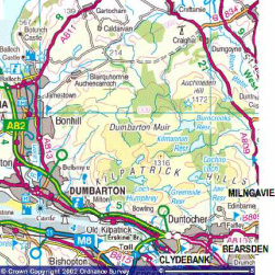
    Pop-up image of road map produced from the Ordnance Survey Get-a-map service. Image reproduced with kind permission of Ordnance Survey.
Powered by Create your own unique website with customizable templates.