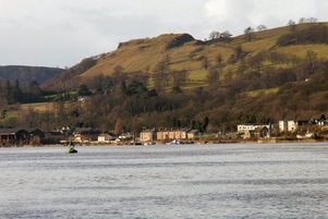
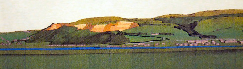
Clydebelt News  - Kilpatrick Hills & surrounding towns
  • Clydebelt News page
  • About Clydebelt
  • contact Clydebelt
  • Clydebelt archive website

Stop the removal of Sheephill

21/6/2012

2 Comments

 
Picture
from this ...

Picture
   ... to this

Clydebelt supports the efforts of the North Bank Environmental Group in their fight against the removal of Sheephill and its Iron Age vitrified fort above the Dunglass roundabout.

Read more for a letter from Clydebelt sent on 19th June 2012.

Read More
2 Comments

What do you think of this blog site?

19/6/2012

2 Comments

 
This blog site is a trial to see if it is better for users, and easier for providers, than the existing blog for Clydebelt  

Please leave a comment on whether it would be better for us to shift Clydebelt's blog to this site.
2 Comments

Clydebelt's response to Local Development Plan

18/6/2012

0 Comments

 
The West Dunbartonshire Council's Local Development Plan covers Clydebank, Dumbarton, Old Kilpatrick, Dalmuir, Parkhall, Duntocher, Hardgate, Faifley, Gartocharn, Jamestown, Bonhill, Bellsmyre, Silverton, Milton and Bowling, and issues such as housing, access, conservation, planning, environment, greenbelt, community, regeneration, archaeology, wildlife, habitats, landscape, wind farms and supermarkets. It includes a National Park and a Regional Scenic Area

(Other plans cover Milngavie, Bearsden, Glasgow, Drumchapel, Craigton, Carbeth, Croftamie, Mugdock and Blanefield).


Read more for Clydebelt's comments on the recent consultation about the Main Issues, which is the first stage in producing a new plan.

Read More
0 Comments
    Picture

    Clydebelt 

    This news/blog site continues from an earlier one at:

    Clydebelt's 2009-2011 blog
    Clydebelt original site
    email Clydebelt
    Kilpatrick Hills on Flickr

    Archives

    November 2015
    April 2015
    March 2015
    January 2015
    November 2014
    July 2014
    April 2014
    January 2014
    November 2013
    October 2013
    August 2013
    May 2013
    April 2013
    January 2013
    December 2012
    November 2012
    September 2012
    June 2012
    April 2012
    March 2012
    January 2012
    March 2011

    Categories

    All
    Forestry
    Greenbelt
    Kilpatrick Hills
    Local Plan
    Meeting
    Planning Issue
    Quarry
    Windfarm

    RSS Feed

    Picture
    Pop-up image of road map produced from the Ordnance Survey Get-a-map service. Image reproduced with kind permission of Ordnance Survey.
Powered by Create your own unique website with customizable templates.