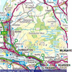
Over the past two years, the number of walkers and cyclists in the Kilpatrick Hills has increased. At weekends and on fine days the narrow access road at the bottom, which leads past the gas governor station and up to the Rosie Road, was often lined on both sides with cars. This was causing concern on the part of the farmers and other residents who live up in the hills; at times there was barely enough space for farm machinery to get through. Emergency vehicles could also have had a problem getting through. There are approximately fifteen separate dwellings - including a farm - accessed from that small road.
The Council agreed to put barriers up each side of the lane to discourage people from parking there, in order to keep the lane free for local traffic and emergency traffic. At the same time as the barriers were put up, signs were put up directing walkers to park their cars up near the O.K. Bowling Club. Admittedly it's not an immediately obvious route there, but signs have been put up directing cars to this parking area. (the signs read ‘P’ Kilpatrick Hills’). Drive up Mount Pleasant Drive, and once at the top turn left over a small bridge that takes you towards the Bowling Club. Parking spaces can be found on the grass there, with additional parking, some 50 m. further along on the left - there is a fair amount of space.
Some people are ignoring the barriers but on the whole there has been a marked improvement, and reduction of the traffic problem at the bottom of the road to the Hills. So next time you are in the area, you’ll spot the signs leading to the new parking area. On a clear day, it is a beautiful walk. There is a steady climb up to the top of the Braes, which is steep for one or two short sections only. The views open up more and more as you get higher up: down the Clyde as it widens towards the Firth, and also back and across over Glasgow. Once at the top, there are miles of tracks and paths, and various lochs. A good walk from the Dumbarton end is up through Overtoun to the Crags, on to the Black Linn through the new forestry path, now much improved, to the west end of Loch, Humphrey and then down the Braes - much easier than going up! You can then get a train back to Dumbarton from Old Kilpatrick.
Forest Enterprise are hoping, in a long term plan, to find a parking solution that is closer to the Kilpatrick Braes so that visitors have easier access to the hills and reduce the impact on residents.
E.P.

 RSS Feed

