| newsletter_january_2013.doc |
|
After the AGM on 20th November, Nick Everett from SNH will talk on the ‘changes and pressures on the Kilpatrick Hills’
----<>---- Tea coffee and biscuits Save Sheep Hill
Don’t know where Sheep Hill is? Well you certainly must have noticed the distinctive flat topped hill above the Dunglass roundabout west of Bowling. On the summit is the site of a scheduled ancient monument- an Iron Age vitrified fort, the woods to the side are supposed to be protected by a WDC Tree Preservation Order (TPO) 1975 and most of the area is designated as a Site of Importance for Nature Conservation(SINC). The area is part of the Kilpatrick Hills Regional Scenic Area and the Glasgow and Clyde Valley Structure Plan especially mentioned that the South-west facing slopes of the hills should be free from further quarrying. Despite all this the hill may be removed in the near future by quarrying! Permission was first given, on appeal, by the Scottish Office in 1949. Attempts to have the quarry owners, Wm.Thompson & Son, exchange Sheep Hill itself for an extension to the North-east failed, although a similar exchange of ground with quarrying consent, immediately adjacent to housing on Milton Hill, for a North-west extension was agreed. Historic Scotland in the face of a possible claim for financial compensation, removed the Scheduling from the Fort that would have prevented any quarrying as permission to which had been given in 1949. The North Bank Environment Group are staging a last ditch campaign to have the removal of the hill stopped. They claim that only intervention by the Scottish Government can save Sheep Hill; and they have printed a leaflet giving a Government website which invites individuals to protest against issues they feel about strongly. Please go there to register your ‘Save Sheep Hill’ appeal. Receipt of the letter we sent to WDC Chief Executive Joyce White, supporting the NBEG was not acknowledged and a follow up achieved a reply that the letter had been received and passed to Jim McAloon, Head of Housing and Regeneration for his information. In reply to a letter from the NBEG, Mr McAloon had previously stated that the Revision of old Mineral Permissions (ROMP) the council ‘was minded-to –approve’ in 2005 for the Quarry, removing Sheep Hill itself, under new working conditions, an [‘approval’] which “The Council has continued to progress due to the benefits that the ROMP will bring to the local community and area. It will allow [Sic] the quarry to work under modern working conditions, regarding operating and blasting hours with wider environmental and landscape benefits”. We fail to see how the removal of, part of a wooded slope under a tree protection order, a hill with a Scheduled Ancient Fort, a Local (WDC) designated Site of Nature Conservation and a prominent feature of our landscape, all to be replaced with a gaping hole in the hillside, can in any way be termed “wider benefits”. If you feel strongly about this contact your councillors and/or MSP. Contacting officials in WDC at this stage would appear to be a fruitless waste of time. The NBEG are taking the issue to the Scottish Public Service (SPS) ombudsman. Sewage in Duntocher Burn Recent contamination of the burn seems to have originated at the Roman Bridge in Duntocher. Scottish Water are now by-passing the bridge with a replacement pipe beside the pedestrian bridge downstream. An email was sent to the West of Scotland Archaeological Society asking that the remains of the Duntocher Corn mill and Forge as well as any Roman remains should be looked for during any excavations. We got no acknowledgement. The Great Outdoors Festival 1st – 8th September Up and around the Campsies, Kilpatricks and Trossachs. The programme for these events by Stirlingshire, West and East Dunbartonshire Councils, has been published and available in libraries and other public places. Online copies can be seen at HYPERLINK "http://www.west-dunbarton.gov.uk/outdoorsfestival" \o "blocked::http://www.west-dunbarton.gov.uk/outdoorsfestival" www.west-dunbarton.gov.uk/outdoorsfestival With particular relevance to the Kilpatrick Hills and surroundings are Sun 2nd 19. Dumbarton Foreshore- Geology, Birds and Battles Tues 4th 27. Gavinburn and Loch Humphrey Hike Wed. 5th 30. Why, Where and What’s the Whangie? Sat. 8th 40. Lang Craigs Circular Path Walk 44. Lang Craigs Community Tree Planting Festival This event is the first tree planting at the Woodland Trust’s new Lang Craigs woodland at Maryland Farm with the launch ceremony at 11.00 free refreshments, live music, guided walks. Shuttle bus from WDC car park at Garshake from 10.15. The event area is near Overtoun House Contact 01738 635829 or email to:[email protected] 45. Antonine Wall Wander A walk along the line of the World Heritage Roman Wall, from its most Western point in Europe at Old Kilpatrick fort, to the forts at Duntocher and Castlehill. Minibus return to Old Kilpatrick Contact 0141 956 6586 or mail to [email protected] Other events recommended from personal experience are the Kelvin Canoe Paddle and the Trees of the World in Balloch Park but look at the programme –there’s something for everyone. Dalmuir Park Restoration Project Community Day Sat 1st Sept. 12.00- 4.00pm Activities include Archery, pony rides, crazy golf, face painting, hook the duck, kiddie’s rides, Information stall, barbeque, nature quiz and much more. Information from Community Engagement Officer Sandra Anton 0141 952 6074 Saltings Litter-Pick Sunday 2nd September 10.00am- 2pm. Started after the gale in January, this has become a monthly event on the first Sunday of the month. Litter is continually washed up by the wind and tide as well being deposited by the usual means. Come along and help keep West Dunbartonshire’s only Local Nature Reserve clean. Meet in the car park off Erskine Ferry Road at 10.00am or down by river whenever you can come. Next Clydebelt meeting is on Sept 16th 7.30pm. Trinity Church, Roman Road, Hardgate 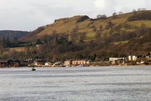 from this ... 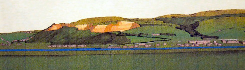 ... to this Clydebelt supports the efforts of the North Bank Environmental Group in their fight against the removal of Sheephill and its Iron Age vitrified fort above the Dunglass roundabout.
Read more for a letter from Clydebelt sent on 19th June 2012. The West Dunbartonshire Council's Local Development Plan covers Clydebank, Dumbarton, Old Kilpatrick, Dalmuir, Parkhall, Duntocher, Hardgate, Faifley, Gartocharn, Jamestown, Bonhill, Bellsmyre, Silverton, Milton and Bowling, and issues such as housing, access, conservation, planning, environment, greenbelt, community, regeneration, archaeology, wildlife, habitats, landscape, wind farms and supermarkets. It includes a National Park and a Regional Scenic Area
(Other plans cover Milngavie, Bearsden, Glasgow, Drumchapel, Craigton, Carbeth, Croftamie, Mugdock and Blanefield). Read more for Clydebelt's comments on the recent consultation about the Main Issues, which is the first stage in producing a new plan. 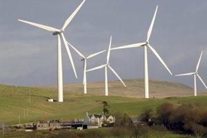 Clydebelt has objected to this proposed wind farm planned for Auchenreoch Muir on the Kilpatrick Hills just east of Pappert Hill above Bonhill.
The ten turbines would be 120m high and fully visible from much of Loch Lomondside and that area of the National Park as well as from Dumbarton, the Vale of Leven and much of the area from Balloch to Stirling. They will be very prominent from almost anywhere in the Kilpatrick Hills Several Clydebelt members met with Stuart Chalmers, District Forester for the Scottish Lowlands and Matt Buckland, Beat Forester for the Kilpatrick Hills. With the acquisition of land at Gavinburn and Merkins, the Commission is now engaged in developing a Forestry Design Plan for all their land in the Kilpatricks to last over the next 20-30 years. This should be completed by September 2013 after several public meetings and consultations at several venues in the area. One of the reasons for the meeting was concern raised by several members at the temporary closing (with diversion) of the Old Kilpatrick to Loch Humphrey track. This has to be brought up to standard to allow access for machinery and not, as was feared by some, to allow large scale extraction of timber.
Any problems you may have about forestry land can be addressed to Matt Buckland at the Clydebank office 01419514510 M. 07825 403622 [email protected] We have had several people expressing fears about the future plans for the hills now that the F.C. is the major land owner. Concerns are that many of the moorland areas will be converted to coniferous forest which might require heavy ridging at the planting stage making walking difficult as well as spoiling the wide open spacious aspects that make walking in the Kilpatricks so special. The woods planted years ago are now ready for extraction but by what routes? From around Loch Humphrey this might be down past Sheephill Quarry through Milton village already plagued by quarry traffic, Or down that scenic road across Kilpatrick Braes which would require considerable ‘upgrading’. Other options might be to extend roadways across from Burncrooks; again not favoured as it could be making the Kilpatricks too accessible to motorised off road vehicles again destroying the ‘feeling’ of remoteness. The objectives of the CSGN Study should have a considerable influence on the FC’s plans. The Kilpatrick Hills Study for the Central Scotland Green Network (CSGN) was done on behalf of West Dunbartonshire Council (WDC) and the Final Report completed. A PDF version of it can be downloaded f by going to a Download link: http://www.2shared.com/document/5h7HYGFm/Kilpatrick_Hills_CSGN_Study_FI.html and entering the password Clydebelter when asked. Then click on the Download button. This is an 8MB file.
A management committee is being set up and so far there are council employee representatives from WDC, EDC and Stirlingshire, the Forestry Commission and Scottish National Heritage. They have formed a steering committee who appointed further members. Clydebelt was recently asked by Land Use Consultants to fill in a questionnaire, on behalf of West Dunbartonshire Council. This took the form of four question sheets, each related to the five main aims of the Central Scotland Green Network (CSGN) http://www.centralscotlandgreennetwork.org/
In particular, each of the four asked about the possibilities or barriers to economic development etc. Clydebelt does not consider that the Kilpatrick Hills is a place for economic development; in fact our response was to emphasis that the hills should be kept as undeveloped as possible, as a place to go to escape the stresses of modern living. The aims of the CSGN and the Scottish Government’s National Planning framework can be found by using the above link. To see Clydebelt’s full response http://www.clydebelt.org.uk/land-use-consultants-questionaire.pdf |

Clydebelt
This news/blog site continues from an earlier one at:
Archives
June 2017
Categories
All

Pop-up image of road map produced from the Ordnance Survey Get-a-map service. Image reproduced with kind permission of Ordnance Survey.
|
||
 RSS Feed
